


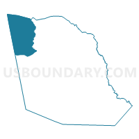
1094 - UNDINE COURTHOUSE Voting District, Evans County, Georgia
About
Outline

Summary
| Unique Area Identifier | 561394 |
| Name | 1094 - UNDINE COURTHOUSE Voting District |
| County | Evans County |
| State | Georgia |
| Area (square miles) | 17.65 |
| Land Area (square miles) | 17.22 |
| Water Area (square miles) | 0.42 |
| % of Land Area | 97.60 |
| % of Water Area | 2.40 |
| Latitude of the Internal Point | 32.23702010 |
| Longtitude of the Internal Point | -81.98957810 |
Maps

Graphs
Select a template below for downloading or customizing gragh for 1094 - UNDINE COURTHOUSE Voting District, Evans County, Georgia


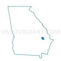
Neighbors
Neighoring Voting District (by Name) Neighboring Voting District on the Map
- 0318 - SINKHOLE Voting District, Bulloch County, GA
- 0431736 - CANDLER - 1736 Voting District, Candler County, GA
- 1093 - CANOOCHEE COURT Voting District, Evans County, GA
- 1096 - EVANS CO CTHOUSE Voting District, Evans County, GA
- 1097 - BELLVILLE Voting District, Evans County, GA
- 2672 - LONGVIEW Voting District, Tattnall County, GA
- 2674 - MANASSAS Voting District, Tattnall County, GA
Top 10 Neighboring County Subdivision (by Population) Neighboring County Subdivision on the Map
- Collins CCD, Tattnall County, GA (3,601)
- North Evans CCD, Evans County, GA (3,122)
- Register CCD, Bulloch County, GA (2,542)
- Pulaski CCD, Candler County, GA (2,407)
- Aline CCD, Candler County, GA (1,752)
Top 10 Neighboring Unified School District (by Population) Neighboring Unified School District on the Map
- Bulloch County School District, GA (70,217)
- Tattnall County School District, GA (25,519)
- Evans County School District, GA (11,000)
- Candler County School District, GA (10,998)
Top 10 Neighboring State Legislative District Lower Chamber (by Population) Neighboring State Legislative District Lower Chamber on the Map
Top 10 Neighboring State Legislative District Upper Chamber (by Population) Neighboring State Legislative District Upper Chamber on the Map
Top 10 Neighboring 111th Congressional District (by Population) Neighboring 111th Congressional District on the Map
Top 10 Neighboring Census Tract (by Population) Neighboring Census Tract on the Map
- Census Tract 9501, Tattnall County, GA (3,601)
- Census Tract 9502, Candler County, GA (3,500)
- Census Tract 9701, Evans County, GA (3,122)
- Census Tract 1108, Bulloch County, GA (2,542)
- Census Tract 9503, Candler County, GA (2,407)